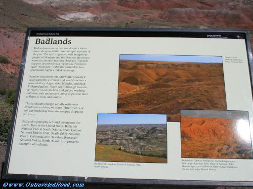
Badlands
Badlands was a term that could send a shiver
down the spine of the most intrepid explorer of
the past. The term originated with indigenous
people of Montana and the Dakotas, the phrase
mako sica literally meaning "badland." Spanish
trappers described such regions as el malpais,
again, "badlands." Today the term refers to a
spectacular, highly eroded landscape.
Summer thunderstorms and winter snowmelt
easily carve the soft shale and sandstone into a
maze of sharp ridges, steep hillsides, and deep
V-shaped gullies. Water drains through tunnels,
or "pipes" inside the hills and gullies, washing
out loose soils and undermining slopes that later
collapse as sinks and slumps.
This landscape changes rapidly with every
cloudburst and drop of water. Three inches of
woil can wash away from the steepest slopes in
ten years.
Badland topography is found throughout the
world. Here in the United States, Badlands
National Park in South Dakota, Bryce Canyon
National Park in Utah, and Tehodore Roosevelt
National Park in North Dakota also preserve
examples of badlands.
[Picture captions]
Painted Desert
badlands at Petrified
Forest National Park.
Badlands at Theodore Roosevelt National Park,
North Dakota.
Badlands in Pakistan. Worldwide, badlands represent a
wide range of geologic time. These in Pakistan, of the
Miocene epoch, are millions of years younger than those
you see here in the Painted Desert.

Don't miss the rest of our virtual tour of Petrified Forest National Park in 1519 images.